You have imported custom polar data. If you edit it here, your imported polar data will be modified and likely significantly simplified in order to fit the data entry screen.
Are you sure you want to proceed?
When switching between "Sail" and "Power", FastSeas will generate a new "Simple" polar and your existing polar will be replaced/lost.
Are you sure you want to proceed?
AS IN BEER
BILLED $60 ANNUALLY
BILLED MONTHLY
BILLED $45 EVERY 6 MONTHS
Secure credit card payment
Your subscription is now active. Your subscription renewal date is .
FastSeas is a sailing passage planning tool. It will calculate the fastest route to take you from point A to point B given the current NOAA GFS weather forecast, current oceanic currents, the performance of your vessel, and your comfort criteria.
FastSeas is created by Jeremy Waters. Jeremy is a lifelong sailor with extensive cruising experience spanning the Western Mediterranean (Costa del Sol, Balearics, Algeria), Eastern Caribbean (Virgin Islands through Trinidad, Venezuela, and Bonaire), throughout The Bahamas, US Gulf and East coasts (Florida through Chesapeake), and a transatlantic.
If you have feedback, suggestions or questions, please email them to me.
 
              Can't find your answer?
We're here to help. Get in touch and we'll get back to you as soon as we can.
NOAA publishes GFS model data four times a day. The approximate times that FastSeas acquires these new data are shown below:
               
            
FastSeas is a sailing passage planning tool. It will calculate the fastest route to take you from point A to point B given the current NOAA GFS weather forecast , current oceanic currents , the performance of your vessel, and your comfort criteria.
October 29, 2025
This is a mostly a "plumbing update" - meaning we've updated the internal workings of FastSeas. You may notice a few minor style changes, but most things work the same way they used to.
Notable changes:
Overall, changes are pretty minor and intuitive. If you encounter any issues or odd behavior, please let me know.
Cheers,
Jeremy
FastSeas is a weather routing and passage planning tool. It will calculate the fastest route to take you from point A to point B given the current NOAA GFS weather forecast, oceanic surface current forecast, the performance of your vessel, and your comfort criteria.
Feel free to look around, but before you can actually run routing calculations, you'll need to log in. Logging in allows FastSeas to remember your polar and comfort criteria. You can log in using various social login options. I have taken this approach rather than having you register with a username and password because it's less work for me and safer for you - as I don't have to deal with passwords. There is nothing nefarious going on here. FastSeas is not going to be reading your posts or creating posts or any such thing.
You need to teach FastSeas about the performance of your vessel. You do that using the Vessel Performance tab. You only have to setup these performance settings once. FastSeas will save these settings and use them next time you come back. There are instructions on the Vessel Performance tab, so I won't repeat them here. The amount of data you have to enter on the Vessel Performance tab can look intimidating, but it goes pretty quickly.
Before FastSeas can calculate a route, you need to tell it where you are starting from and what your destination is. You do that using the Routing tab. On the Routing tab, you'll see a map with an "S" marker and a "F" marker. These represent your start and finish points. They can be positioned by dragging them on the map. Or if you prefer, you can enter the Lat & Long into the fields.
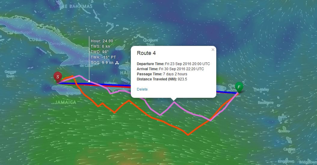
You can now run weather routing calculations by clicking the Calculate Route button on the Routing tab. After the calculation is complete, the route will be displayed on the map. You can also look at the details of the route on the Route Positions tab, and summary stats on the Passage Stats tab.
You can specify your comfort criteria on the Routing tab. You can enter the maximum wind speed in knots that you are willing to tolerate beating (forward of the beam), reaching (aft of the beam), and maximum gust conditions.
Note that you can run multiple calculations, perhaps with different departure times, comfort criteria, or destinations, and have all of these routes displayed in the same map.
You can also get routing and departure planning solutions from FastSeas via email (e.g. Iridium GO!, Sailmail, Winlink, and other email services) and via Garmin inReach and other short message satellite communicators such as Zoleo, Spot, and Bivy Stick devices. This is particularly useful when offshore or in remote anchorages - when you don't have access to high-speed internet. Results are provided by an automated email responder, which automatically calculates the route or departure planning result in response to your emailed request, and sends the result back to you in a reply email within a few seconds. Using the email responder service requires a FastSeas subscription.
To request a route using the email responder service, send an email like the one below:
To: query@fastseas.com Subject: Bonaire-Porlamar SEND ROUTE: 12.0N, 68.3W, 10.9N, 63.8W
                    Where
                    12.0N,68.3W
                    are the coordinates of your departure point (in decimal
                    degrees) and
                    10.9N,63.8W
                    are the coordinates of your destination. The subject is not
                    consequential - you can make it whatever you like. You can
                    also specify coordinates in degrees and minutes if you
                    prefer as shown below:
                  
To: query@fastseas.com Subject: Bonaire-Porlamar SEND ROUTE: 12-0N, 68-18W, 10-54N, 63-48W
                    Where
                    12-0N
                    is 12 degrees 0 minutes North, and
                    68-18W
                    is 68 degrees 18 minutes West.
                  
A few minutes after sending your email, the automated email responder will send you a reply containing a GPX file which contains your routing solution. The GPX file contains waypoint data for your optimum route. Each waypoint contains predicted weather data for that waypoint in the waypoint description field. GPX files can be imported into a variety of chart plotters and navigation software (e.g. Navionics "Boating" app, OpenCPN, iNavX, Coastal Explorer, etc.). The GPX file is typically very small (less than 5 KB) and therefore very suitable for low bandwidth HF or satellite access.
The automated email responder will only respond to requests from authorized email addresses. That includes the email address you registered with, or to any email address you setup in the Account tab - where you can authorize your Iridium GO, SailMail, Winlink, and other email addresses.
                    If you prefer to get a Google Earth KMZ file instead of the
                    standard GPX response, add a
                    KMZ
                    switch to your request as shown below:
                  
To: query@fastseas.com Subject: Bonaire-Porlamar SEND ROUTE: 12.0N, 68.3W, 10.9N, 63.8W, KMZ
                    If you would like to receive a compressed GPX file (zipped),
                    then use a
                    GPXZIP
                    switch instead.
                  
                    If you would like to limit the number of days included in
                    the route mailed back to you, then add a
                    DAYS=3
                    switch, substituting the number of days you wish to receive:
                  
To: query@fastseas.com Subject: Bonaire-Porlamar SEND ROUTE: 12.0N, 68.3W, 10.9N, 63.8W, GPXZIP, DAYS=2
                    You can also receive the routing data in a table (CSV file)
                    using the
                    CSV
                    switch.
                  
                    The default departure time for routing request submitted via
                    the email responder in "now." You can adjust the departure
                    time using the optional
                    DEPARTURE_DELAY_HOURS
                    parameter. For example, use
                    DEPARTURE_DELAY_HOURS=2
                    to set the departure time to two hours from now; or use
                    DEPARTURE_DELAY_HOURS=24
                    to set the departure time to this time tomorrow (24 hours
                    from now).
                  
                    You can optionally include parameters to adjust your comfort
                    criteria. To set the maximum wind you are willing to
                    tolerate forward of the beam, use
                    MAX_WIND_BEATING=20
                    (e.g. 20 kn). Use
                    MAX_WIND_REACHING=30
                    to set the maximum wind you are willing to tolerate aft of
                    the beam. Use
                    MAX_WIND_GUST=50
                    to set the maximum wind gust you are willing to tolerate.
                  
                    If you would like to disable ocean current effects in the
                    routing calculation, add a
                    NO_CURRENT
                    switch to your request.
                  
                    You can also optionally include parameters to adjust your
                    polar performance and motoring criteria. To set the polar
                    performance adjustment, use
                    PERFORMANCE_ADJUSTMENT=90
                    (e.g. 90%). Use
                    START_MOTORING=3
                    (e.g. 3 kn) to set the boat speed at which you will start
                    motoring. Use
                    MOTORING_SPEED=7
                    (e.g. 7 kn) to set the speed at which you motor.
                  
You can also get departure planning results from FastSeas via email. To get departure planning results, send an email like the following:
To: query@fastseas.com Subject: Bonaire-Porlamar SEND DEPARTURE: 12.0N, 68.3W, 10.9N, 63.8W
The reply email will contain an attached table with your departure planning data.
The FastSeas email responder also supports Garmin inReach and other short message satellite communicators such as Zoleo, Spot, and Bivy Stick. Messages on these devices are generally limited to 160 characters of plain text - and so this imposes some limitations on what FastSeas can send.
InReach devices usually automatically provide your current location in messages sent from the device, so there is no need to provide your current/start position latitude and longitude when submitting routing and departure planning requests from your inReach device. If you wish to specify a departure position different from the position automatically reported by you inReach device, then you certainly may include both departure and destination positions in your request.
                    When sending a request from an inReach device, you must
                    include the EMAIL parameter, specifying the
                    email address you registered with (see the Account
                      tab). This is required because messages from inReach devices do
                    not provide a reply email address.
                  
Example routing request:
To: query@fastseas.com SEND ROUTE: 10.9N, 63.8W, EMAIL=JEREMY@FASTSEAS.COM
                    When sending a request from Zoleo, Spot, Bivy Stick, or
                    other short message satellite communicator device, you must
                    include the
                    SHORT
                    parameter, which tells FastSeas to respond using the short
                    message format. You must also include both the start and
                    destination latitude and longitude.
                  
Example routing request:
To: query@fastseas.com SEND ROUTE: 12.0N, 68.3W, 10.9N, 63.8W, SHORT
                    Some devices may require reply messages to be shorter than
                    160 characters. For example, Spot devices have a 140
                    character limit. You can configure different maximum reply
                    message length using the
                    MSGLEN parameter as shown in the example below:
                  
To: query@fastseas.com SEND ROUTE: 12.0N, 68.3W, 10.9N, 63.8W, SHORT, MSGLEN=140
Response messages are limited to 160 characters, so FastSeas will by default send a single compact reply message - consisting of the next 4 positions along the optimum route at 6 hour intervals. For example:
HOUR,LAT,LNG,WIND,COG H0,11.58N,67.75W,15G18@78,126 H6,11.17N,67.16W,16G19@81,126 H12,11.04N,66.65W,10G14@110,59 H18,11.34N,66.02W,6G7@114,54,M
Where (looking at the first row of data):
| Code | Description | 
|---|---|
| H0 | Indicates the elapsed time in hours to reach the waypoint. H0 is the start point, now, at hour 0; H6 is 6 hours from now, etc. | 
| 11.58N,67.75W | Latitude and longitude in decimal degrees | 
| 15G18@78 | Wind 15 knots, gusting 18, from 78 degrees true | 
| 126 | Course over ground (true) from this waypoint (H0) to the next waypoint (H6) | 
| M | A trailing "M" in a row of data indicates that you would be motoring | 
                    If you need more waypoints, you can send a request with the
                    optional
                    WAYPOINTS
                    and
                    INTERVAL
                    parameters, where
                    WAYPOINTS
                    determines how many waypoints will be sent (default is 4
                    waypoints), and
                    INTERVAL
                    determines how many hours between each waypoint (default is
                    6 hours). For example:
                  
To: query@fastseas.com SEND ROUTE: 10.9N, 63.8W, EMAIL=JEREMY@FASTSEAS.COM, WAYPOINTS=24, INTERVAL=4
The example request above will send 24 waypoints with 4 hour interval between each waypoint. If you request more data than can fit in a single 160 character message, then FastSeas will reply with multiple messages. The example request above will result in a chain of 6 messages being sent in reply.
Departure planning responses to inReach and short message devices are similarly brief. The default response will include a single day (departing today) of departure planning stats sent in a single messages. Example request:
To: query@fastseas.com SEND DEPARTURE: 10.9N, 63.8W, EMAIL=JEREMY@FASTSEAS.COM
Example response:
PLAN 1 DEP 16 APR 14:34Z TIME 2d4h MOTOR 0h W-MIN 11 W-MAX-BEAT 19 W-MAX-REACH - W-GUST 25 W-AVG 17 %BEAT 100 %CLS 0 %BEAM 0 %BRD 0 %RUN 0 BS-AVG 6.8
Where:
| Code | Description | 
|---|---|
| DEP | Departure date and time in UTC | 
| TIME | Passage duration, where 2d4h means 2 days and 4 hours | 
| MOTOR | Time motoring | 
| W-MIN | Minimum wind (knots) | 
| W-MAX-BEAT | Maximum wind beating (knots) | 
| W-MAX-REACH | Maximum wind reaching (knots) | 
| W-GUST | Maximum wind gust (knots) | 
| W-AVG | Average wind (knots) | 
| %BEAT | Percent of the time beating | 
| %CLS | Percent of the time close reaching | 
| %BEAM | Percent of the time beam reaching | 
| %BRD | Percent of the time broad reaching | 
| %RUN | Percent of the time running | 
| BS-AVG | Average boat speed (knots) | 
                    You can request several days of departure planning results
                    by specifying the optional
                    PLANS
                    parameter in your request. The example request below
                    requests 5 days of departure planning stats, which will
                    result in 5 separate response messages being sent to your
                    inReach device:
                  
To: query@fastseas.com SEND DEPARTURE: 10.9N, 63.8W, EMAIL=JEREMY@FASTSEAS.COM, PLANS=5
| Commands, Parameters, and Abbreviations | Description | 
|---|---|
| SEND ROUTE,SR | Requests an optimum routing calculation | 
| SEND DEPARTURE,SD | Requests an departure planning calculation | 
| KMZ | Requests route as a KMZ file rather than GPX | 
| GPXZIP | Requests route as a zipped GPX file | 
| CSV | Requests route as a CSV file rather than GPX | 
| DAYS,D | Limit the size of the returned route to the specified number of days | 
| DEPARTURE_DELAY_HOURS,DDH | Delay the departure time by the specified number of hours (from "now") | 
| MAX_WIND_BEATING,MWB | Specifies the maximum wind you are willing to tolerate forward of the beam | 
| MAX_WIND_REACHING,MWR | Specifies the maximum wind you are willing to tolerate aft of the beam | 
| MAX_WIND_GUST,MWG | Specifies the maximum wind gust you are willing to tolerate | 
| NO_CURRENT,NC | Disables ocean current effects in routing calculations | 
| PERFORMANCE_ADJUSTMENT,PERF | Used to adjust the performance of the vessel from what the polar would suggest - where "100" is the nominal polar derived performance | 
| START_MOTORING,SM | Specifies the minimum boat speed below which you will start motoring | 
| MOTORING_SPEED,MS | Specifies the motoring boat speed | 
| SHORT | Used with short message satellite communicators to force the short response message format (160 character max). Required for Zoleo, Spot, Bivy Stick, etc. | 
| MSGLEN | Used with short message satellite communicators to set the desired maximum reply message length (short format only; optional; defaults to 160) | 
| EMAIL,E | Associate your inReach request with your FastSeas profile (inReach only - required for all inReach requests) | 
| WAYPOINTS,WPT,W | Specifies the number of waypoints to return (short format only; optional; defaults to 4) | 
| INTERVAL,INT,I | Specifies the number of hours between waypoints (short format only; optional; defaults to 6) | 
| PLANS,P | Specifies the number of departure plan days to return (short format only; optional; defaults to 1) | 
A polar diagram is a common way of depicting vessel performance in various wind conditions. The diagram plots boat speed at various true wind angles and wind speeds. The true wind angle is indicated around the edge of the semicircle. Boat speed is then plotted at various true wind speeds - different color lines representing different true wind speeds. The boat speed is indicated as the distance from the center of the circle. Concentric circles indicate boat speed starting at zero in the center of the circle and extending out at 2, 4, 6, 8, and 10 knots boat speed.
Edit the polar diagram for your vessel by entering boat speed values in the table below. In this table there are four columns for different true wind angles. True wind angles measure the direction of the win relevant to the bow of the vessel. A true wind angle of 0° represents wind coming directly from the bow, and 180° represents wind coming directly from the stern. Sailing vessels should enter the closest point of sail in the first column header. The table has six rows for different true wind speeds (5, 10, 15, 20, 25, 30 knots). In each cell in the table, enter your boat's speed in knots for the given true wind angle and true wind speed. The polar diagram will be automatically updated as you enter this data. Your polar will be automatically saved in your account for reuse on your next visit.
Use this option to import a polar created elsewhere; or to create a more complex polar than is possible using the Edit option above; or to export and save your polar for safe-keeping or for re-use in some other routing application.
Paste your qtVlm, OpenCpn, or iPolar formatted polar data in the window below and click the Import button.
| Elapsed Hours | Date/Time | Latitude | Longitude | Heading | Speed | COG | SOG | Wind Speed | Gusting | Wind Dir | TWA | Ocean Current Speed | Ocean Current Direction | 
|---|
| Statistic | Value | 
|---|
Departure planning will calculate estimated route statistics based on the departure date/time, start location, and finish location that you configure on the Routing tab. It will calculate these stats on one day departure intervals starting with the departure date you specify on the Routing tab. These stats are rough estimates and intended for comparison of potential departure dates.
| Statistic | Plan 1 | Plan 2 | Plan 3 | Plan 4 | Plan 5 | Plan 6 | Plan 7 | Plan 8 | Plan 9 | Plan 10 | Plan 11 | Plan 12 | Plan 13 | Plan 14 | Plan 15 | 
|---|
                          
                        
| Id | Mail2 | Mail3 | DisplayName | Username | Registered | Last Login | Sub Type | Sub End Date | Sub Cancelled | 
|---|