 FastSeas
New FastSeas Routing Engine
22 October 2026
FastSeas has a new routing engine. It is built to handle hard routes: complex coastlines, archipelagos, and weather that changes along the way. It uses the finest global grids the public weather models publish: 0.25 degrees for wind and waves, and 1/12 degree for ocean currents. And it steps through time as finely as each model allows.
New Routing Model Features
- NOAA GFS wind, 0.25 degrees. Hourly for the first five days, then every 3 hours out to 16 days.
- ECMWF wind, 0.25 degrees. Every 3 hours for the first six days, then every 6 hours out to 15 days.
- NOAA RTOFS ocean currents, 1/12 degree (about 0.08 degrees, or 5 miles).
- NOAA GFS-Wave (WAVEWATCH III) waves, 0.25 degrees.
- ECMWF waves, 0.25 degrees.
- Wind, current and waves all act on your boat. The router weighs all three at every step.
- Land avoidance that copes with hard coastlines, including fairways through dense archipelagos.
- Global coverage.
- Your comfort and safety limits respected. Set the most wind and the roughest sea you are willing to sail in, and the route keeps within them, waiting where it has to.
- Notable events along the route, such as thunderstorm risk, squall conditions, heavy rain, and rough or dangerous seas.
- Polars for monohulls, catamarans and trimarans, from light to heavy.
- Optional waypoints along a route.
- A route in seconds. On our users' own routes of 350-650 miles, the calculation takes 2 seconds at the median, and 9 in 10 finish within 3 seconds on GFS and 5.5 seconds on ECMWF. Routes of 650-1,500 miles take 3-4 seconds at the median. Your wait adds a moment for the queue and the page.
- Weather at every point along the route: wind and gusts, current, the sea (height, period and direction), air temperature, cloud cover, rain, and CAPE (the energy available to thunderstorms).
- Motoring by your settings. The route motors when the wind is too light by your rules, and your motoring speed slows in the wind and sea it meets.
Fifteen Classic Courses
A router is easy to show on an easy route. So we sailed the new engine on fifteen classic courses: ocean races, famous passages, and a few that are hard for any router. Among them are the Transpac, the Sydney Hobart, the Chicago Mac, the Newport Bermuda, Cape Town to St Helena, and Cape Town to Melbourne across the Southern Ocean.
Each course starts and finishes a few miles off its harbour, in open water. Each was sailed on both forecast models, GFS and ECMWF, at three departure times a day apart, with ocean currents and waves on and no motoring. That is 90 routes.
All 90 arrived. Every course, on both models, at every departure.
Three boats sailed them, each from a published polar:
- TP52 and First 40.7: from the ORC's 2024 certificates, the middle-rated boat of each class.
- Volvo 70, on four of the long courses: a Volvo Open 70's published polar.
The hours below are the middle of the three departures on each model. They come from one week's forecasts, so they are this week's weather, not a passage's typical time. The polars also stop at 20-24 knots of wind and are held flat above that, so hours in stronger winds are a little quick. Calc time is how long each route took to calculate, from its fastest to its slowest run.
| Course | Boat | GFS: miles sailed | GFS: hours | ECMWF: miles sailed | ECMWF: hours | Calc time |
|---|---|---|---|---|---|---|
| Cape Verde to Barbados | Volvo 70 | 2,246 | 180 | 2,216 | 172 | 8-10 s |
| Cape Town to Melbourne | Volvo 70 | 5,713 | 365* | 5,738 | 361* | 17-41 s |
| The Hague to Genoa, through Gibraltar | Volvo 70 | 2,475 | 277 | 2,541 | 238 | 9-12 s |
| Alicante to Cape Verde | Volvo 70 | 2,068 | 184 | 2,096 | 175 | 7-8 s |
| Transpac: Los Angeles to Honolulu | TP52 | 2,564 | 224 | 2,543 | 225 | 7-10 s |
| Heraklion to Palma de Mallorca | TP52 | 1,241 | 152 | 1,211 | 142 | 4-6 s |
| Chicago Mac: Chicago to Mackinac Island | TP52 | 303 | 42 | 303 | 36 | 0.7-0.9 s |
| Sydney Hobart | TP52 | 633 | 45 | 639 | 49 | 1.6-2 s |
| Mangonui to Stewart Island | TP52 | 978 | 94 | 999 | 96 | 3-4 s |
| Newport Bermuda | First 40.7 | 652 | 65 | 653 | 64 | 2-2.5 s |
| La Rochelle to Las Palmas | First 40.7 | 1,397 | 192 | 1,426 | 219 | 7-8 s |
| Manila to Davao | First 40.7 | 845 | 145 | 848 | 163 | 8-11 s |
| Cape Town to St Helena | First 40.7 | 1,846 | 232 | 1,850 | 231 | 7-8 s |
| Sydney to Auckland's west coast | First 40.7 | 1,157 | 125 | 1,150 | 131 | 4 s |
| Cork to La Coruña | First 40.7 | 500 | 55 | 505 | 58 | 1.4-1.5 s |
* Cape Town to Melbourne takes about as long as the forecasts reach. GFS runs out at 16 days and ECMWF at 15, and this passage takes 15-16 days. On five of its six runs the last part was sailed on the forecast's final hour, held. So read it as proof that the route arrives, and take its hours with a pinch of salt.
Some of these courses are hard for a router. Manila to Davao threads through the islands of the Philippines: the route sails about 850 miles for a course 554 miles apart in a straight line. Mangonui to Stewart Island is free to go down either side of New Zealand. And The Hague to Genoa has to find its way round Spain and Portugal and through the Strait of Gibraltar.
We should be honest about where we started. The FastSeas of 2020, routing on 1-degree GFS wind alone, failed three of these fifteen courses: The Hague to Genoa, Mangonui to Stewart Island, and Manila to Davao. Today all three arrive, on both models.
Sample Route: The Hague to Genoa
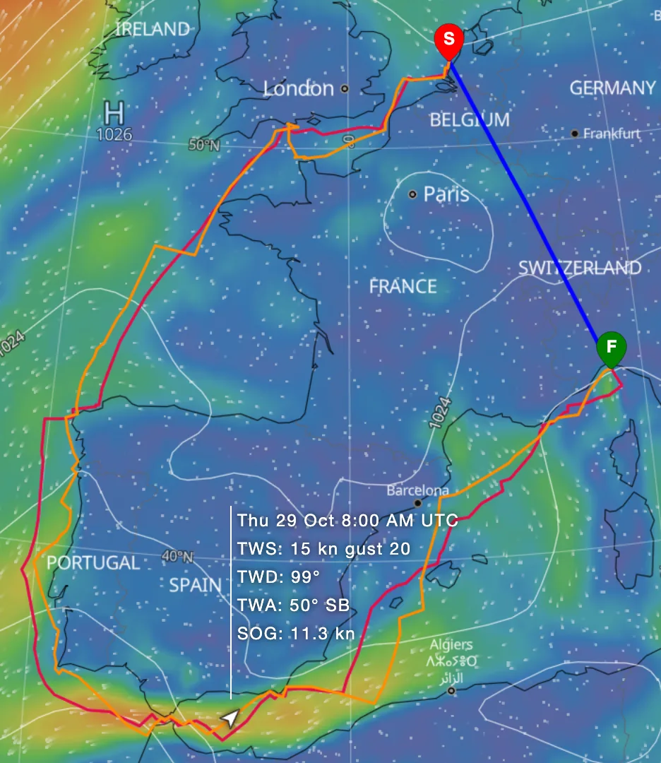
This is one of the hardest of the fifteen for a router. The start is off Scheveningen, The Hague's harbour, in the North Sea. The finish is off Genoa, at the top of the Mediterranean. Between them lie the whole of Spain and Portugal, and one way through: the Strait of Gibraltar, under 8 miles wide at its narrowest. The course has a waypoint in the middle of the strait, so the route must pass through it.
The route has to get round a lot of coastline, through a narrow gap, and across two very different seas: the Atlantic first, then the Mediterranean.
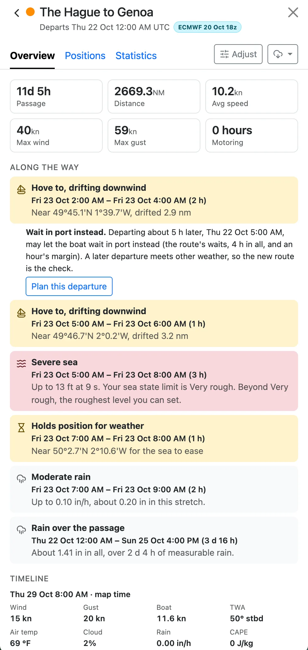
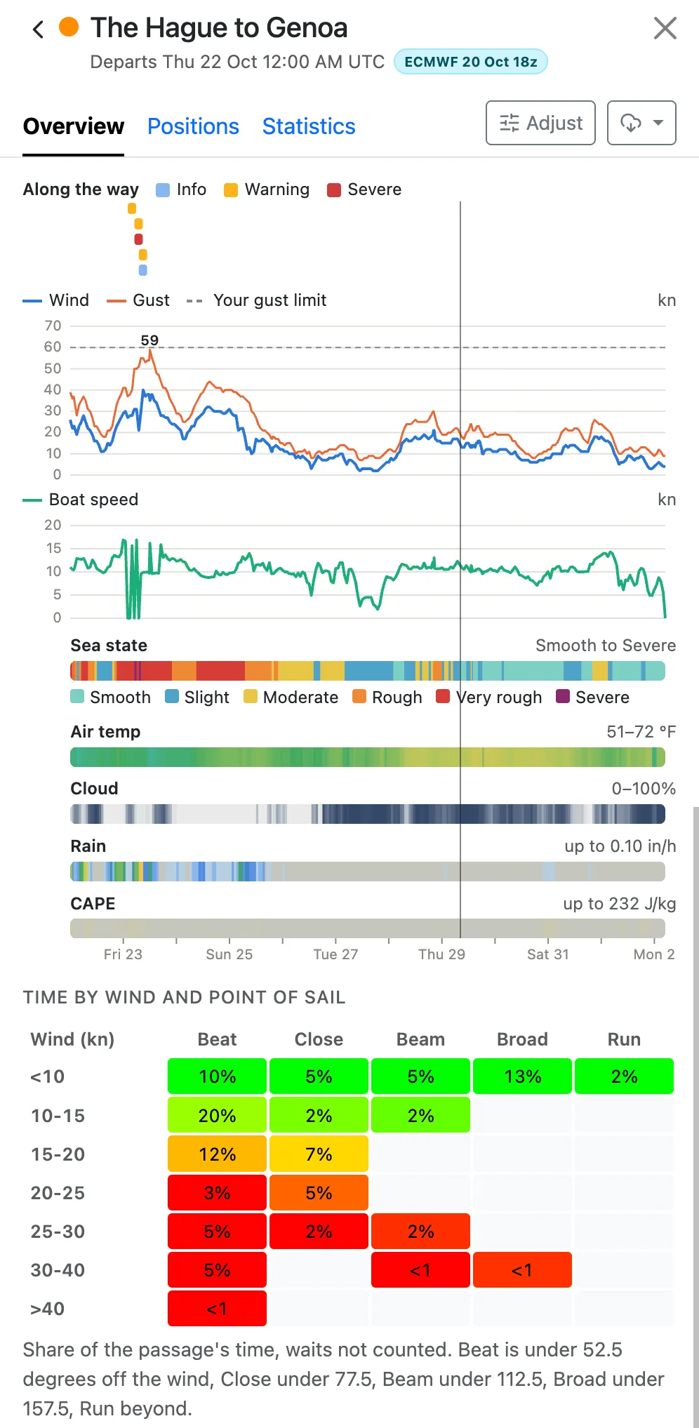
On this week's weather, the Volvo 70 sailed 2,441-2,580 miles, taking 231-281 hours, or 10-12 days. Each route took 9-12 seconds to calculate.
The two models did not agree. On GFS the middle of the three times was 277 hours; on ECMWF, 238, about a day and a half less. That is a good reason to look at both before you go: run the same route on GFS and on ECMWF, and compare.
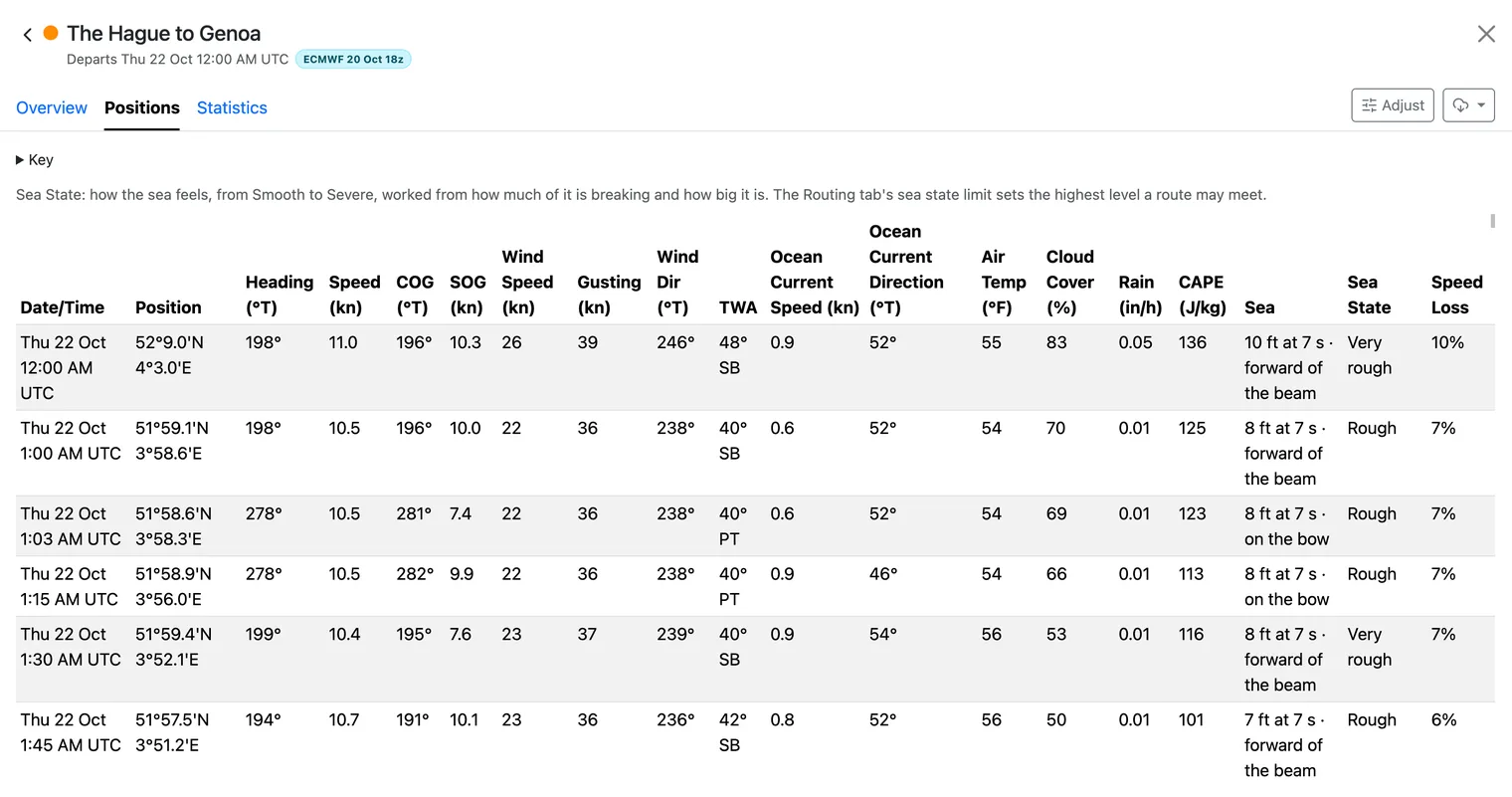
Every point along the route carries its weather: the wind and gusts, the current, the sea's height, period and direction, the rain, and CAPE for thunderstorm risk. You can see where the hard parts of the passage are, and when you will meet them.
Sample Route: Manila to Davao
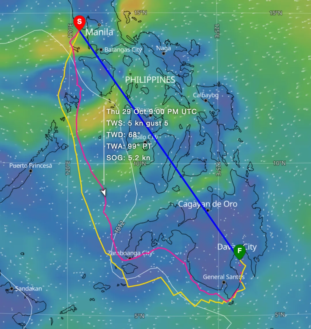
Manila and Davao are 554 miles apart in a straight line, with the islands of the Philippines in between. The route has to find a way through them, among narrow passages and headlands.
The First 40.7 sailed 821-865 miles over the six runs, taking 130-181 hours. The middle departure took 145 hours on GFS and 163 on ECMWF. Each route took 8-11 seconds to calculate.
When you leave matters here. On GFS, leaving two days later added more than two days: 130 hours from the first departure, 181 from the last.